Introduction:
The purpose of this lab is to learn how to download and map data from the US Census Bureau.Methods:
Objective 1: Download 2010 Census Data
To achieve this objective, I navigated to the US Census Bureau Fact Finder Website and utilized the Advanced Search function. Under the Topics option, I chose "People, Basic Count/Estimate" and then "Population Total." Under the Geography option, I chose "County 050," "Wisconsin," and "All Counties in Wisconsin." Then, I scrolled through the provided data and located the variable P1 for Total Population from the 2010 SF1 Dataset. I downloaded this file to my personal Lab 2 folder, extracting all files from the provided zip file.
Objective 2: Download Shapefile of 2010 Census Boundaries
To achieve this objective, I navigated once more to the US Census Bureau Fact Finder Website and utilized the Advanced Search function again. Under the Geographies option, I selected the Map tab, noting that the Wisconsin counties were highlighted. I then downloaded this information to my personal Lab 2 folder, extracting all files from the provided zip file.
Objective 3: Join Downloaded Data to Census Shapefile
To achieve this objective, I first opened up a blank map in ArcMap, being sure to save the file to my personal Lab 2 folder. Then, I renamed the Layers data frame as "Population" and added the 05_00 shapefile (acquired in Objective 2) and the P1 table (acquired in Objective 1) to the map. After this, I joined the two data files through clicking on the shapefile, selecting "Joins and Relates" and then "Join." Upon opening the shapefile's attribute table, the joined data is visible in the last column entitled D001, which contains population data.
Objective 4: Mapping Data
Objective 3: Join Downloaded Data to Census Shapefile
To achieve this objective, I first opened up a blank map in ArcMap, being sure to save the file to my personal Lab 2 folder. Then, I renamed the Layers data frame as "Population" and added the 05_00 shapefile (acquired in Objective 2) and the P1 table (acquired in Objective 1) to the map. After this, I joined the two data files through clicking on the shapefile, selecting "Joins and Relates" and then "Join." Upon opening the shapefile's attribute table, the joined data is visible in the last column entitled D001, which contains population data.
To achieve this objective, I needed to add a new field to the 05_00 shapefile, since the original D001 field was imported as a string field type and could not be mapped quantitatively. This involved opening the shapefile's attribute table, selecting "Add Field," naming the new file (D001_new), and choosing the field type to be "Double." Then, I right-clicked the newly added field, opened the Field Calculator, and selected the original D001 field. After this, I was able to map Wisconsin's population by utilizing the shapefile's "Properties" window to select D001_new in the "Value" field as well as choose an appropriate color ramp and number of classes.
Objective 5: Mapping Another Variable
To achieve this objective, I returned to the US Census Bureau Fact Finder Website and selected another variable to download, namely Total Housing Units in Wisconsin by County. I then followed the steps listed above in Objectives 2, 3, and 4 to download, unzip, and add, join, and map the data.
Objective 6: Configure Map Layout
Objective 7: Create Webmap
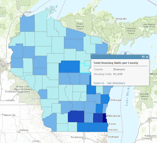
To achieve this objective, I made a copy of my map document, as I wanted to preserve my original maps as well as create a new document displaying just the housing data for a webmap. I then logged into my ArcGIS Online Account inside ArcMap. After making necessary adjustments to the new document, I shared and configured my map through creating a web map service on ArcGIS Online.
Results:
 |
| Figure 1: Maps displaying demographic and housing data |
 |
| Figure 2: Interactive webmap displaying WI housing data; located on ArcGIS Online here |
The results of my methods are displayed above. Figure 1 depicts both population and housing data; as would be expected, the maps are similar in that in locations where more people are present, there are more houses.


