Introduction:
The purpose of this lab is to utilize various geoprocessing tools for vector analysis in ArcGIS to determine a suitable habitat for bears in the study area of Marquette County, Michigan.Methods:
Objective 1: Map Black Bear Locations
To achieve this objective, I first opened ArcCatalog, navigated to my personal Lab 3 folder and examined the data stored there, taking note of the data's coordinate system. Then, I used the search function in ArcHelp to read more about adding x,y coordinate data as a layer. To add the bear locations as an XY event theme, I navigated to File, Add Data, and Add XY Data, filling out the pop up window with appropriate information. This included choosing "bear_locations_geo$" as the table as well as choosing the correct coordinate system, NAD_1983_HARN_Michigan_GeoRef_Meters.
Objective 2: Determine Forest Types
To achieve this objective, I added all of the feature classes from the bear_management_area data set to a data frame. I then changed the symbology of the landcover feature class to "unique values" based off of the MINOR_TYPE value field, choosing an appropriate color scheme. In order to determine the bear habitat, I performed a Spatial Join between the bears_locations and landcover feature classes to generate a new feature class which displays both the ID number of the bear and the land cover type in which it was found in the attribute table. After this, I used the Summarize tool on the MINOR_TYPE field to generate a table displayed the number of bears found in each type of habitat. The top three habitat types were Mixed Forest Land, Forested Wetlands, and Evergreen Forest Land.
Objective 3: Examine Black Bears & Streams
To achieve this objective, I utilized Select By Location to discover how many bears were found within 500 meters of a stream. Upon doing this, I found out that 72% of bears were found near streams, thus making this an important criterion in determining suitable bear habitats. I then performed a Buffer on the streams layer to create a buffer of 500 meters around the streams feature class.
Objective 4: Determine Suitable Black Bear Habitat Regarding Streams & Landcover
To achieve this objective, I first performed a Query upon the landcover feature class to select the top three habitat types and created a separate feature class from this selection. Then, I performed an Intersect using that landcover_top3 feature class and the streams500 feature class created in Objective 3. I then used the Dissolve tool to remove the internal boundaries.
Objective 5: Determine Suitable Black Bear Habitat in Michigan DNR Areas
To achieve this objective, I first added the dnr_mgmt feature class to my ArcMap document. Since this feature class included superfluous information about DNR areas in all of Marquette County, I performed a Clip using the study_area feature class to create a feature class showing only the DNR areas within the study area. Then, I performed a Dissolve upon the newly created feature class to remove the internal boundaries. After this, I used the Intersect tool on the dnr_mgmt and landcover_top3 feature classes.
Objective 6: Eliminate Unsuitable Areas
To achieve this objective, I first performed a Query on the landcover feature class to select all of the Urban or Built Up land, creating a separate feature class entitled urbanland from this selection. Then, I used the Dissolve tool to remove the internal boundaries. After this, I performed a Buffer of 5 kilometers on the urbanland feature class. Then, I utilized the Erase tool, using dnr_mgmt as the input and urbanland as the erase feature to create the output feature class final_hab, which displays the suitable areas for bear habitats.
Objective 7: Create Map & Data Flow Model
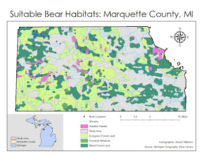
To achieve this objective, I created a cartographically pleasing map that displayed suitable areas for bear habitats. After this, I created a data flow model depicting the steps I used during this lab. Both the map and data flow model are displayed below in the Results section.
Objective 8: Python Application
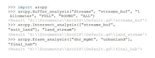
 |
| Figure 1: Python Commands |
To achieve this objective, I utilized Python in ArcMap to write buffer, intersect, and erase commands using the bear habitat data.
Results:
 |
Figure 2: Data Flow Model |
 |
| Figure 3: Final Map |
The results of my methods are displayed above.
Sources:
Center for Shared Solutions and Technology Partnerships. (2014). Michigan Geographic Framework: Marquette County. Retrieved from http://www.mcgi.state.mi.us/mgdl/framework/metadata/Marquette.html.Michigan Center for Geographic Information. (2002). Michigan 1992 NLCD Shapefile by County. Retrieved from http://www.mcgi.state.mi.us/mgdl/nlcd/metadata/nlcdshp.html.
Michigan Department of Natural Resources. (2001). Wildlife Management Units. Retrieved from http://www.mcgi.state.mi.us/mgdl/nlcd/metadata/nlcdshp.html.
State of Michigan. (2015). GIS Open Data. Retrieved from http://gis.michigan.opendata.arcgis.com/