Goal and Background:
The purpose of this lab was to learn about various spatial data sets and how to accurately present them through creating a basic report featuring base maps. This report concerns the Confluence Project, a new development in downtown Eau Claire, Wisconsin which will serve as a community arts center, university student housing, and a commercial retail complex.Methods:
Objective 1: Explore various data sets for the City and County of Eau Claire
To achieve this objective, I used ArcMaps and provided spatial data to become familiar with the Eau Claire Geodatabase. As a part of this, I explored various feature datasets, feature classes, including data regarding parcels, zoning, topology and census.
Objective 2: Digitize the site for the proposed Confluence Project
To achieve this objective, I created a new geodatabase in ArcCatalog. I then added a feature class to this geodatabase, and imported the BlockGroups data from the Eau Claire Geodatabase. After that, I added the pro_site feature class to the same data frame. In order to begin the digitizing process, I opened the Editor Toolbar and utilized it to digitize the Confluence Project area.
Objective 3: Learn about the Public Land Survey System
To achieve this objective, I first inserted a new data frame and added a basemap imagery layer. I then added the PLSS_Townships feature dataset from both of the Eau Claire Geodatabases. Using the Properties window, I added numbers to the PLSS sections as well as utilized a stretched color scheme to highlight patterns. I then identified the specific PLSS section in which the Confluence Project was located.
Objective 3: Learn about the Public Land Survey System
Objective 4: Create a legal description for parcels and generate basic site report
To achieve this objective, I navigated to the City of Eau Claire's Property Search website. After zooming in on Eau Claire and locating the two parcels involved in the Confluence Project, I clicked on each of them to collect the information needed to write a proper legal description for the parcels. I also took a screenshot of each parcel selected and displayed its parcel ID. The finished product is displayed below.Brief legal descriptions for Confluence Project properties' location of site in Public Land Survey System:
I. PARCEL 1
 |
| Figure 1: Parcel 1 |
Parcel Number: 02-0365
PIN: 1822122709200042068
Street Number: 128
Street Name: Graham Ave.
Owner's Name: Haymarket Concepts LLC
Owner's Address: PO Box 617
Owner's City, State, Zip: Eau Claire, WI 54702
Legal Descriptions: LOTS 1-2-3-4-5-6-7-8 BLK 62 & THE 26 FT W OF E 84 FT OF LOTS 9 & 10 & EX E 140 FT ALL OF LOTS 9 & 10 BLK 62 VILLAGE OF EC ADD TID 8
II. PARCEL 2
Parcel Number: 02-0363
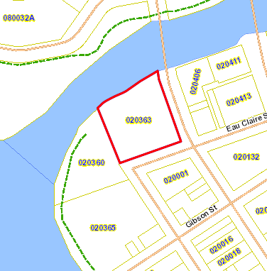 |
| Figure 2: Parcel 2 |
Street Number: 202
Street Name: Eau Claire St.
Owner's Name: Haymarket Concepts LLC
Owner's Address: PO Box 617
Owner's City, State, Zip: Eau Claire, WI 54702
Legal Descriptions: PRT OF BLK 58 IN GOV LOT 4 BEING REPLATTED AS LOT 1 CSM 3037 REC V 17 P 95 DOC 1109271 LOC IN GOV LOT 4 SEC 20-27-9 TID 8 **FOR 2015 COMBINED PARCELS 02-0360-A, 02-0357, 02-0358, 02-0359, 02-0361, 02-0362
Objective 5: Build a layout with each of the major thematic feature classes
To achieve this objective, I created six different basemaps presenting various relevant data about the Confluence Project (Figure 1, below). The maps addressed Civil Divisions, Census Boundaries, PLSS Features, EC City Parcel Data, Zoning, and Voting Districts.Process: To neatly organize my data, I utilized rulers and guidlines to set up six data frames. I then added basemap imagery data to each data frame, as well as an appropriate title. Each map required adding different data from the Eau Claire Geodatabases, and then adjusting transparency levels and color schemes to assure a pleasing map. After the data was in place, I inserted a scale bar (in miles) as well as a legend for each map.
Results:
The results of my methods are displayed below in the form of six basemaps. Together they present useful information which could aid developers in decisions concerning the Confluence Project construction. |
| Figure 3: Finished Project |
Sources:
City of Eau Claire, WI (2015). City of Eau Claire Property Search. Retrieved from http://eauclairecitywi.wgxtreme.com/Zoning Districts and Maps (2011). Eau Claire. Retrieved from Q:\StudentCoursework\CHupy\GEOG.335.001.2161\LAB\lab1
Lippel, Irene D. (2000). Understanding Wisconsin Township, Range and Section Land Descriptions. Geological and Natural Historical Survey. Retrieved from Q:\StudentCoursework\CHupy\GEOG.335.001.2161\LAB\lab1
No comments:
Post a Comment